

Las Vegas's Premier Flying Club - Giving You A Reason to Fly!
By Lauren Scott, DFC Flight Instructor
The area near Jean Airport (0L7), 15-25 miles southwest of Henderson Executive Airport, is a popular area for general aviation flights. It can be very quiet one minute, and extremely busy the next, so it’s important to stay vigilant and keep an eye out for traffic, as well as to use recommended uncontrolled airport radio communications. Pilots can operate more safely and efficiently when they know what to expect when flying in this area, so read on for a familiarization with Jean operations! Typical operations at Jean include student airplane and helicopter training flights in the surrounding area and in the traffic pattern, skydiving, aerobatic maneuvers in a marked aerobatic box, glider and glider towing flights, as well as VFR and IFR traffic transitioning to and from the busy Las Vegas area.
As always, please consult the most recent VFR sectional charts, chart supplement, and current NOTAMS for the most accurate information, as the following information may change.

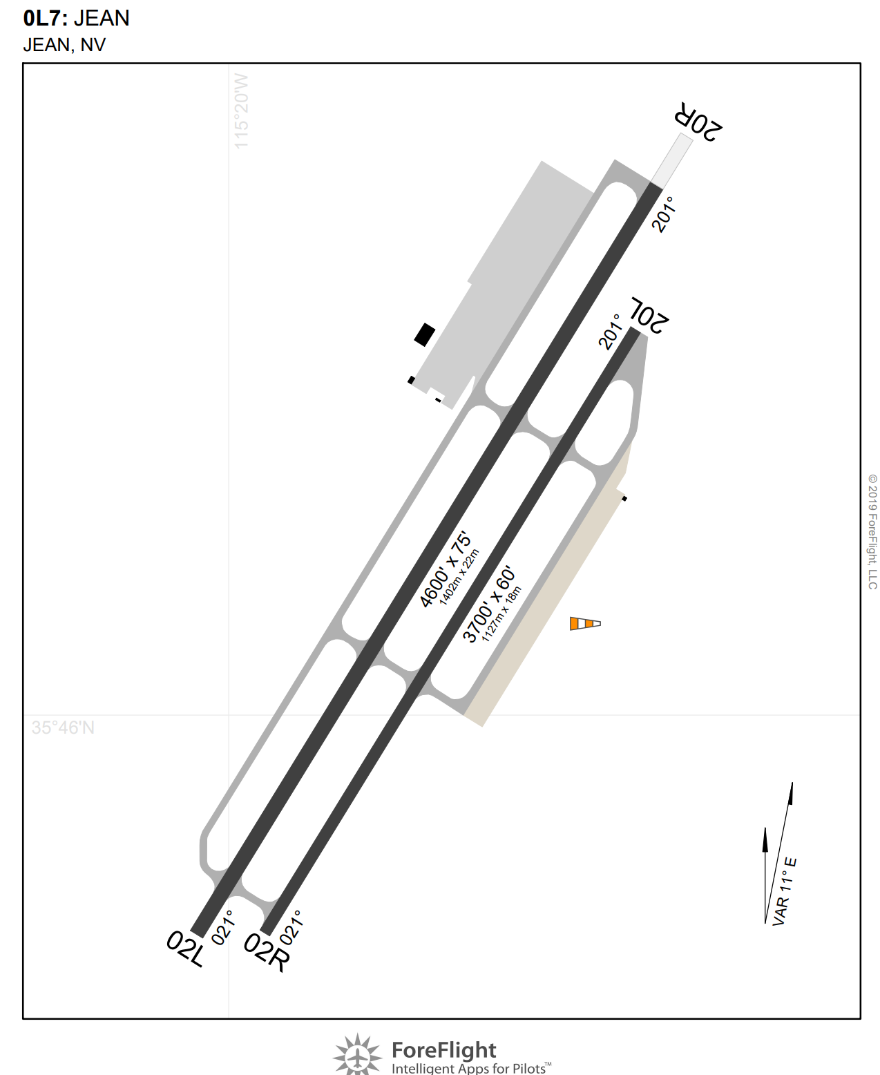
When transitioning to Jean from Henderson, be sure to remain clear of the Bravo airspace. Just on the east side of the I-15 abeam the Sloan mine area, there is a racetrack. Here, head west of the I-15, and stay at least ½ mile west, as northbound traffic will often fly on the east side. The Bravo shelf here is 5000’, so most planes fly at or below 4500’ MSL in both directions. Once clear of the Delta airspace, look for “The Ruins,” a visual checkpoint where the railroad tracks pass under the I-15. Switch the comm radio over to Jean CTAF on 122.9 and monitor for a moment to listen for traffic in the area. Following the recommendations for approaching or operating in the vicinity of uncontrolled airports, report your distance and direction from Jean, and your intentions. (i.e. “Jean Traffic, Archer 55167, 10 miles north at 4,500, inbound for landing, Jean.”) Usually, other pilots in the vicinity will also report their position in response. As noted in the chart supplement, there are parallel runways: 2L/2R, and 20L/R. The longer west runways are most often used for airplanes taking off, landing, and practicing pattern work, and have a left pattern for 2L, right pattern for 20R. The east runway is shorter and more frequently used for glider operations and helicopter work. As noted in the chart supplement, powered aircraft are to use the traffic pattern to the west, and are asked to make an entry from the west side of the field. Because there is a prison to the northeast, as well as steep terrain, pilots are to avoid flying over that area.

Pilots should approach the pattern from the west. There is no ASOS or AWOS available at Jean, but if other aircraft are in the pattern or on the ground, you can listen or ask on CTAF to find out which runway the wind favors for landing. If not, the surface wind is usually, but not always, coming from the same direction as at Henderson. There are a few windsocks located between the runways at each end, and midfield on the east side of 2R/20L in the segmented circle. A large American flag at a casino to the northwest of the field can also be observed for wind information. If entering a left pattern for 2L, be aware of the aerobatic box area 3 miles west of the airport (depicted by white L and T shape markers on the ground), and enter the left downwind at a 45 degree angle, reporting as you join downwind. The traffic pattern altitude at Jean is 3600’; note that it’s 800’ AGL–lower than a standard 1000’ pattern.
To land southbound on 20R, fly west to make a wide circle around the aerobatic box markings, then enter the right downwind on a 45 degree angle for 20R. Look out for power lines near the departure end of all runways and utilize the best angle of climb speed after takeoff to expedite the climb.
There are daily skydiving operations at the Jean airport. The pilots of the jump planes will make regular announcements of their position and when they’re dropping jumpers, but they climb and descend very quickly to and from around 15000’, so pay close attention to their radio calls. They drop the skydivers at 2 locations: a dirt lot on airport property west side of 2L/20R, and sometimes also on the north tip of the Roach Dry Lake Bed (4 miles south of the airport). As long as GA pilots are flying a normal, closed pattern, and staying mindful of the location of the parachuters and pilots, they may safely operate while the parachute operations are being conducted. However, pilots who are unsure of the operations or drop zone locations should remain clear of the airport until the jumpers are on the ground. The jump planes enter and exit the pattern at high speeds and high rates of climb and descent. If you are flying in the pattern while they are operating, please consider flying a wider pattern and coordinate letting them land or takeoff first since they are much faster than most small general aviation planes.
Noted on the first chart above in orange, there are generally four distinct areas used by student pilots as practice areas: over the Jean Dry Lake Bed (4 miles northeast of Jean), over and to the south of Goodsprings (6 miles west/northwest) along the mountain range, the Roach Dry Lake Bed (4 miles south), and the Ivanpah Dry Lake Bed (10 miles south). If there is a pilot already practicing in one area, it is good practice to go to the next one, as the pilot will often be maneuvering at higher altitudes for items like stalls and slow flight (5000-6000 MSL) as well as ground reference maneuvers (3300-3700 MSL). Following recommended uncontrolled radio procedures, pilots are encouraged to monitor the Jean CTAF (122.9) while operating in these areas, make frequent position reports, make regular clearing turns before all maneuvers, and maintain situational awareness of other traffic operating in the airspace. It is also very helpful to utilize a portable ADS-B In device such as a Stratux or Stratus. (Some of the club aircraft already have these installed, but most do not.)
When departing from the Jean traffic pattern or the practice area, there are helpful procedures to follow to maintain safe separation from other traffic. To depart to the north from a right pattern on 20R, make normal right upwind, crosswind and downwind legs, and then depart northbound on the downwind leg. Fly north of the airport for about 2-3 miles on the west of the I-15 up to 4500’ so as to avoid other traffic in the pattern, then fly eastbound to reposition over to the east of the I-15 to continue flying northbound. Make frequent radio calls to announce your location and intentions, on downwind, when leaving the pattern, transitioning to the east of the I-15, over the colorful rocks (7 Magic Mountains), and before reaching The Ruins checkpoint.

After listening to ATIS, monitor HND Tower to get a mental picture of what is currently happening in the pattern there. Call HND Tower at the Ruins and expect instructions on which runway to use and how to enter the pattern. For 17R, the directions will most likely be to enter a right downwind and report midfield. For 35L, the directions will usually be to enter and report a 2 mile left base, or to make and report a 3 mile final. Occasionally, depending on traffic, they will direct you to continue to fly northbound toward the M Resort, then fly directly east bound to enter downwind (in which case make sure to fly under the 4000’ Bravo shelf to the southwest of the M). Coming in from Jean, please be especially vigilant of other traffic that may be departing Henderson to the southwest, and make sure you stay on the east side of the I-15.
The Jean airport and practice areas are valuable nearby areas that can be used by pilots for checkrides, maneuvers and pattern work, and knowing the local procedures and flow of traffic can make flying there safer and more enjoyable.